The countdown is on to the big day and each day we’ll give an update on the chances of a white Christmas and a rough idea of what weather to expect for the big day. You will find the updates below.
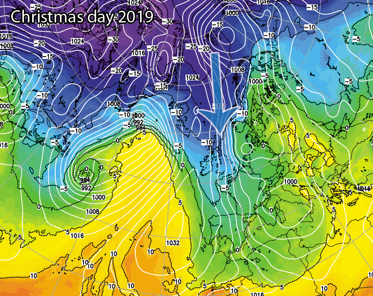
Update #3 – 11th December
Well well well.. The models are actually showing something much colder for the big day. Whilst I would take it with a pinch of salt at the moment, perhaps a small pinch for the time being, the ensembles from the models are showing colder scenarios for the big day, nothing set in stone yet but I’m sure you’ll enjoy the ups and downs of these daily updates.
The latest chart from Christmas shows a cold northerly flow developing with snow on Christmas day across Scotland and then Christmas night into Boxing day we see snow showers packing in across northern and eastern areas, especially North Sea facing coasts with snow showers also running along western coasts and Northern Ireland.
Could we be onto something? Check back tomorrow to see if the models show the same… If you require more regular weather information and the best weather tools and resources then upgrade to Pro today by clicking here.
Update #2 – 10th December
Slightly better output this morning for Christmas day and boxing day with a northerly flow showing, initially bringing snow showers to Scotland and the model output also shows an area of low pressure sliding up from the southwest drawing in colder air on the northern flank which could perhaps turn rain to snow across some central and southwestern areas. The risk however would be relatively low. The model then shows the brief northerly and colder air filtering south into Boxing day with sleet and snow showers across northern areas and along North Sea facing costs. A better update this morning if you’re looking for a colder Christmas. Still a long way to go, are the models onto something or will it be back to mild south/south-westerlies in tomorrows update? Stay tuned. Check back tomorrow at the same time to see if the models still show a mild Christmas. If you require more regular weather information and the best weather tools and resources then upgrade to Pro today by clicking here.

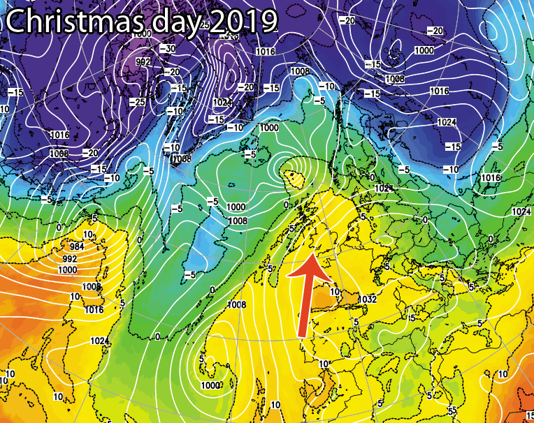
Update #1 – 9th December
If a white Christmas is what you’re looking for then look away now! The models are being rather consistent in showing very mild south to southwesterly winds with a very mild Christmas day showing across the UK at the moment. Whilst it will be mild it is expected to be settled based on the current model outputs with any unsettled weather reserved across the extreme northwest of the United Kingdom (W/NW Scotland and the western Isles of Scotland). Latest chart for the big day can be found below. Check back tomorrow at the same time to see if the models still show a mild Christmas. If you require more regular weather information and the best weather tools and resources then upgrade to Pro today by clicking here.