
The United Kingdom has certainly experienced a very wet Autumn and winter so far and I’m afraid the wet and generally milder conditions are set to continue, at least throughout most of January. The reason for the unsettled weather is the position and strength of the Jet Stream. The jet stream is a fast flowing current of air higher up in the atmosphere, in fact the jet stream is located near the tropopause with prevailing westerly winds. The strength and position of the Jet Stream is very important to the UK’s weather as it controls our weather patterns, direction of these patterns and at times also the strength of low pressure systems, for example if a rapidly developing area of low pressure catches the Jet Stream at the correct time this can lead to rapid intensification of low pressure systems as they track towards the United Kingdom.
During the Autumn months we would expect the Jet Stream to be strong and positioned all the way across the Mid-Atlantic and slap bang over the United Kingdom which would lead to wet and windy weather dominating our weather via low pressure systems rattling in from the Atlantic. Typically you would expect the winter months to see a weakening Jet Stream with the Jet Stream diving south of the United Kingdom. As a result this would promote the chance of high pressure developing in the Atlantic with low pressure systems slowing down or driving south of the high pressure, building blocks are then in place for height rises towards Scandinavia and then we promote weather systems from the north and northeast of the United Kingdom in the form of much colder air (weather). Sometimes we may even see easterlies developing.
If the Jet stream goes north of the United Kingdom during the Autumn and winter months we would normally see high pressure over Iberia and France (Europe) moving into the UK, whilst it can bring drier conditions it normally wouldn’t bring colder conditions, apart from overnight frosts, especially if we see some cooler upper air being thrown into the mix. During the summer months ideally we want the jet way north of the United Kingdom which would allow milder air under high pressure to develop and move up from the near continent, this would bring heat and at times when we get stagnant areas of low pressure sat just to the west of the UK this can combine with heat to produce a thunderstorm risk.
What is the Jet Stream doing now?
The Jet Stream is positioned across the Atlantic and slap bang over the United Kingdom and as a result low pressure systems are rattling in off the Atlantic bringing some very unsettled weather. This will continue for the next 14-20 days based on current model expectations. During the next 7-10 days or so is when we’ll see some rather potent systems moving in from the Atlantic bringing gale force winds, severe at times and further wet weather. Below is a video animation showing the strength and position of the Jet Stream with sea level pressure for the next 10 days. If you can see the United Kingdom under the Jet Stream and all of those low pressure systems, you’ll find it in the centre of the image.
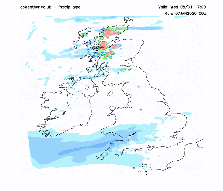
Will we see any snow any time soon?
During the next 7-10 days whilst low pressure will be in charge, we will at times see colder air in between these systems flooding in from the W/NW off the Atlantic. Higher ground of Scotland, Northern Ireland and the hills of Northern England may see some wintry showers at times with snow reserved over the highest ground. One thing we’re keeping an eye on is a low pressure system moving in from the south-west on Wednesday into Thursday. The track and position of the low pressure system is crucial because the model output has hinted at colder air being drawn in on the northern flank of the system which may turn rain to snow, even to low ground in places, however I must emphasise it is a low risk at the moment and the snow risk keeps changing on each model run. You will find an animation from our high resolution model this morning below. Rain is blue, green represents sleet/snow mix and red/pink is snow.
Snow chances at a longer range?
Models and various signals have been toying with the idea of something much colder developing towards the end of January and to start Feb. So this is something we’ll keep a close eye on and we will update you when we have further information. I will say one thing, ignore the Daily express, Daily mail and the various articles floating around social media because they couldn’t be more wrong, significant snowfall and a very cold prolonged spell of weather is not heading towards the United Kingdom..
I hope you enjoyed my blog post. Feel free to join or UK weather group on Facebook by clicking here, we have almost 50,000 enthusiastic members posting brilliant weather content daily!
Article by: Lewis Dobson