
SUMMARY
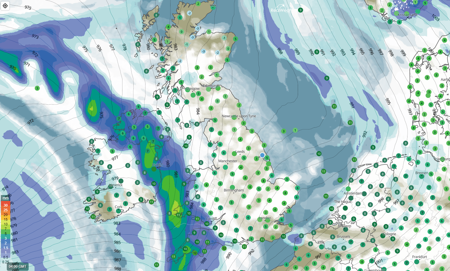
Wet weather moving in from the south-west this morning with strengthening winds across Cornwall, Devon, Somerset and also Irish sea coasts through the day.
A cold start for many northern and eastern areas with a local ground frost overnight. An air frost for rural parts of the far north and north-east of England and up into Scotland with overnight lows dipping down to -5c in Aviemore.
The wet weather will extend northwards and eastwards this morning, eventually clearing away into the North Sea around or just after noon today. Slower to clear across Scotland.
Milder for the southern half of the United Kingdom, cooler in the far north.
FORECAST
A wet start across south-west England, Wales and Northern Ireland with a frontal system moving north and east throughout the morning. Expect some heavier bursts within the system at times. The heaviest rain is currently across parts of SW England and Northern Ireland.
The system will continue to move through across much of England and Wales this morning, bringing a spell of wet weather to many. It will clear away into the North Sea around 12pm/1pm this afternoon.
Winds will remain gusty across south-west England and Irish sea coasts this morning with generally blustery winds extending across much of England and Wales throughout the day. Gusts ranging from 30-40mph, though for exposed locations in the south-west and along Irish Sea coasts, 50mph can be expected at times.
As the frontal system moves into northern areas later this morning, we may see some wintriness to the precipitation over the highest northern hills and then eventually up into the highest ground of Scotland later today. Nothing of significance expected in terms of snow away from the highest tops in Scotland.
In-behind the frontal system we will see plenty of showers, heavy and at times thundery, pack in to western and south-western areas and also NW England, NI and SW Scotland, these will move from west to east this afternoon and continuing well in to the evening/night period.
The thunder risk greatest across Wales and SW England, especially more towards coastal areas where we see the greatest energy due to warm sea surface temperatures for the time of year. This combined with the fact we’re seeing some cooler air aloft giving a steeper temperature gradient to that at the surface.
The showers merging together to bring longer spells of rain at times and extending well inland on blustery winds across the United Kingdom, even east of the Pennines!
Today’s temperatures ranging from 8-11c in the south and 7-9c in the north of England. Head up in to Scotland and temperatures will be even lower. Some parts of Scotland, in and around the central highlands really struggling today with temperatures close to or just above freezing but generally 5-8c for other parts of Scotland.
That’s today’s forecast and the attached image on this post shows positioning of the frontal system forecast for 6am this morning, cloud cover and sea level pressure.
IN VIDEO
Have a great day, whatever the weather.
Lewis