


Christmas Forecast 2018
Are you dreaming of a white Christmas 2018? From now until the big day we will be posting a daily update from our long range forecast model. We use the CFSV2 model which is a medium to longer range forecast model. As we nearer Christmas day we’ll start using our shorter range forecasting models and of course have more of an idea with regards to what weather we’ll see this Christmas. You can find the latest update below. Update #1 – 7th December 2018 Based on the current CFSv2 model output Christmas day 2018 is expected to be a mixed bag. Low pressure is expected to be the dominating feature of our weather as we head …
Read More »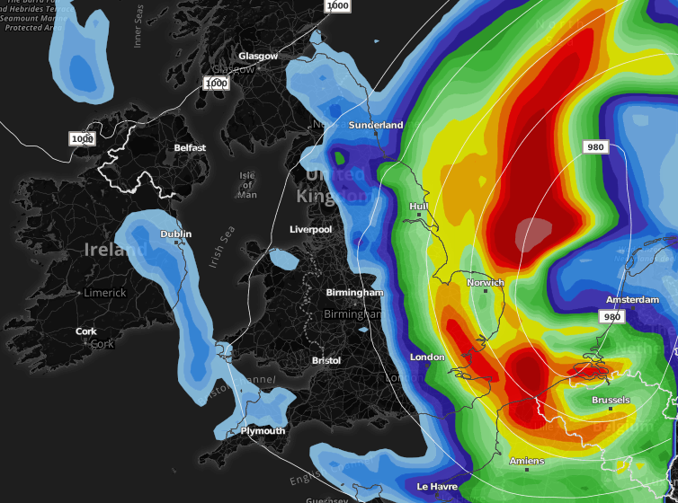
Remaining unsettled and cold with wintry weather for some
We continue with the cold theme for many areas over the next 48 hours or so. The wintry weather will become increasingly confined to northern hills through Saturday night and into Sunday. We stay with the cool east to northeasterly flow which will bring further snow showers, even into Monday across the higher ground in the north, however to lower ground precipitation will be falling as rain, hail and at times sleet. The showers will be heaviest and most frequent across eastern coastal counties of England and Scotland (north sea facing coasts) and we maintain the risk of one or two of these showers being thundery in nature. Whilst many central and western areas remain cold and dry, however …
Read More »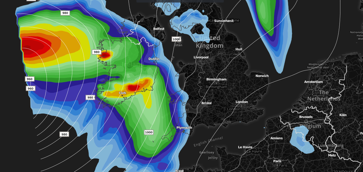
Big low set to bring severe gales and heavy rain for some
An area of low pressure is expected to track close to the United Kingdom late Thursday and will head NNE during Friday morning. Whilst strong winds are associated with this area of low pressure, thankfully many areas will escape the strong winds, however many areas will be blustery during Friday. The low tracks NNE late Thursday night bringing severe gale force winds across much of Ireland and Northern Ireland, especially west and southwest coasts. Strong winds (gale force) will also affect the southwest of England and Irish sea coasts in general. Through Friday the strongest winds then extend northwards into parts of W, SW and NW Scotland including the Western Isles of Scotland. The image below shows expected wind gusts …
Read More »
Nationwide HEATWAVE next week? Or just turning very warm and locally hot?
Another day and yet more heatwave articles doing the rounds on Facebook, my newsfeed is full of them! Well you’ll be glad to know that the weather is improving significantly and by next week much of the UK is likely to be basking in glorious sunshine with the mercury rising, locally hot conditions may develop, particularly across central and southern areas. What most of these click bait weather pages fail to forget (because lets be honest they’re not interested in factual weather information they’re just bothered about the £ sign rather than giving the UK public honest and reliable weather information) is that for each county of England there are temperature thresholds for true heatwave conditions and whilst next week …
Read More »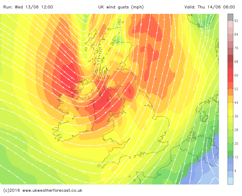
Storm Hector moves in overnight
Storm Hector moves in overnight and he’s expected to bring some unseasonably disruptive weather across northern parts of the United Kingdom. A frontal system associated with the area of low pressure is currently affecting western and northern parts of the United Kingdom and will continue to push eastwards overnight. The heaviest and most persistent rainfall will be west of the Pennines and across West & northwest Scotland. Precipitation (rain) will be patchier in nature on the southern extent of the frontal system. Showers, heavy at times will also rattle in behind the frontal system to affect Northern Ireland, Scotland, northern and northwestern parts of England and western coasts in general during tomorrow. The main emphasis …
Read More »
Next weeks weather could be cracking – early bank holiday indications
Next week is looking pretty good for many areas with high pressure being the dominant feature and whilst it won’t be scorching UK wide some areas may see temperatures creeping into the low-mid twenties. The charts below show 850hpa temperatures and sea level pressure for Monday of next week. As can be clearly seen high pressure is in play and as a result winds will be light with temperatures responding nicely. The yellows and oranges on the 850hpa temperatures and sea level pressure chart represent milder upper air which has an affect on temperatures at the surface. Some of the weather models are indicating a slow change from the west/northwest with cooler air moving into the UK, however it has …
Read More »
Warming up this weekend…
High pressure will be the dominating feature this week leading to more in the way of dry, settled and fine weather. We do have the small matter of some rain across Northern Ireland, Scotland, Northern parts of England and Western areas Tuesday into Wednesday as we see a weakening frontal system plague these areas. There will also be cooler air moving into the northern half of the United Kingdom albeit temporarily. The good news is high pressure will quickly reassert its self with long spells of sunshine, plenty of blue sky and warmer temperatures Thursday onwards and more so during the weekend period. We may just see highs reach the low twenties widely this weekend. The charts below …
Read More »
Significant rainfall across the east and southeast!
An area of low pressure will develop and move up from the south later on Sunday bringing with it some very heavy rainfall for at least a 24 hour period! At the moment areas at greatest risk of disruption are southeastern parts of England (Essex, London & the Home Counties, Sussex and Kent) and also parts of East Anglia. Many areas will widely see rainfall totals in excess of 30mm with perhaps 60mm+ locally, which is of course a flooding concern. As colder air is drawn in on the northern flank of the system we see a risk of rain turning to sleet and snow across the South Downs for example and potentially even to lower levels …
Read More »
Is a heatwave on the way?
There have been many reports from the media suggesting a heatwave is on the way during April, some media sources have even said temperatures may reach the low to mid twenties. Is a heatwave on the way? Let’s take a look at what the weather models are showing. This week sees low pressure in charge and whilst at times there will be some milder temperatures, especially across the southern half of the United Kingdom, many northern areas will continue to see cooler conditions with the risk of further wintry showers and snowfall across the higher ground in the north of England and Scottish hills/mountains. The GFS chart below shows upper 850hpa air temperature and sea level pressure. The greens, blues and …
Read More »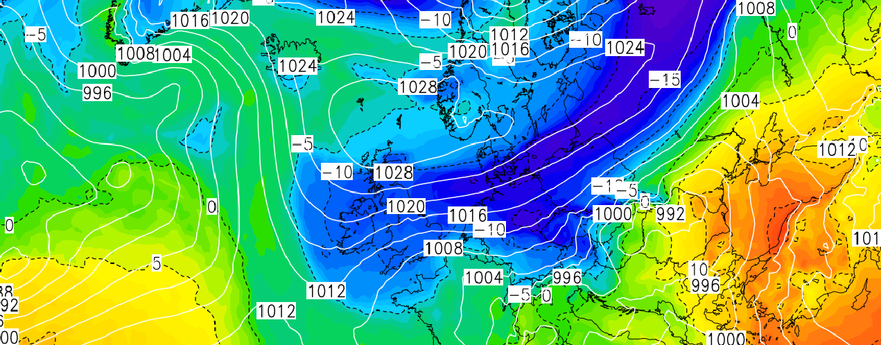
Beast from the East part 2 – How cold and how long will it last?
The latest model outputs continue to show much colder air being sourced all the way from Siberia moving into the United Kingdom this weekend. Initially the weather models had the colder air in the form of an easterly affecting the United Kingdom this Sunday into Monday of next week. The models have now brought the said event forward with the very cold air now expected to hit the United Kingdom this Saturday! Below is a chart from our GFS weather model. Whilst there still remains some uncertainty with regards to how potent the easterly blast will be and how much snow will fall, what I can tell you is that based on the latest model output snow will be in the …
Read More »